Barbara Roden

Roses blooming at the back of a property on Fraser Street in Lytton. (Photo credit: Barbara Roden)

‘Our story has to stay out there or we’ll be forgotten’: Lytton resident

One year after fire nearly wiped out Fraser Canyon town, progress has been slow and painful

Roses blooming at the back of a property on Fraser Street in Lytton. (Photo credit: Barbara Roden)
A mudflow cuts across the access road to a property on Highway 8 east of Spences Bridge on June 3, 2022. Heavy rain and the potential for debris flows has prompted the closure of Highway 1 between Spences Bridge and Lytton. (Photo credit: Mavourneen Varcoe-Ryan)

Highway 1 closed between Lytton and Spences Bridge as proactive measure

Highway will remain closed until the morning of June 4 due to the potential for debris flows

A mudflow cuts across the access road to a property on Highway 8 east of Spences Bridge on June 3, 2022. Heavy rain and the potential for debris flows has prompted the closure of Highway 1 between Spences Bridge and Lytton. (Photo credit: Mavourneen Varcoe-Ryan)
How can you resist this face? Hamsters are one of the small animals available through the BC SPCA’s ‘Little Creatures, Big Hearts’ pay-as-you-can promotion through May 31. (Photo credit: BC SPCA)

BC SPCA holding special adoption event for some unusual potential pets

‘Little Creatures, Big Hearts’ promotion highlights small animals, birds, and reptiles

How can you resist this face? Hamsters are one of the small animals available through the BC SPCA’s ‘Little Creatures, Big Hearts’ pay-as-you-can promotion through May 31. (Photo credit: BC SPCA)
The first train crosses the new controlled, temporary at-grade level crossing of Highway 1 at Tank Hill north of Lytton on Jan. 14. (Photo credit: MOTI)

Highway 1 reopened to traffic between Lytton and Spences Bridge

Highway still closed between Lytton and Hope, due to record snowfall and avalanche risk

The first train crosses the new controlled, temporary at-grade level crossing of Highway 1 at Tank Hill north of Lytton on Jan. 14. (Photo credit: MOTI)
A temporary one-lane Atcow bridge measuring 260-feet-long is being installed on Highway 1 at Jackass Mountain. (Photo credit: MOTI)

Highway 1 through Fraser Canyon scheduled to reopen mid-January

Drivers can expect single-lane traffic and reduced speeds in some locations

A temporary one-lane Atcow bridge measuring 260-feet-long is being installed on Highway 1 at Jackass Mountain. (Photo credit: MOTI)
Route taken by a BC Hydro pole washed away west of Merritt by flooding in November 2021. (Photo credit: BC Hydro)

Hydro pole travels hundreds of kilometres from Nicola River to Boundary Bay

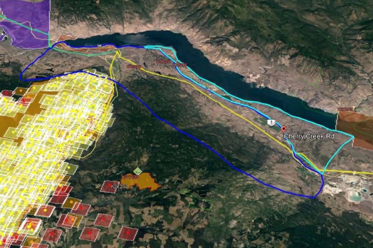
Broken pole found after being washed away following flooding on Highway 8 east of Merritt

Route taken by a BC Hydro pole washed away west of Merritt by flooding in November 2021. (Photo credit: BC Hydro)
Twilight (front) and Harold relaxing at home in Cache Creek after Twilight’s hair-raising adventure. (Photo credit: Angela Taylor)

The cat came back: Twilight returns to B.C. Interior home after 2 month disappearance

Twilight was found at highway rest stop miles from Cache Creek and turned in to PoCo SPCA

Twilight (front) and Harold relaxing at home in Cache Creek after Twilight’s hair-raising adventure. (Photo credit: Angela Taylor)
The TNRD has issued an evacuation order for 37 properties along Highway 8 east of Spences Bridge. (Photo credit: TNRD)

Evacuation order issued for 37 properties along Highway 8 east of Spences Bridge

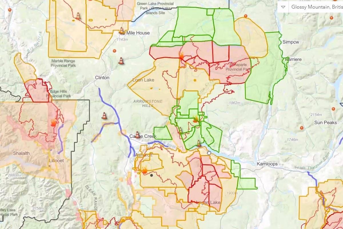
Floodwaters threaten several properties and have severely damaged infrastructure along highway

The TNRD has issued an evacuation order for 37 properties along Highway 8 east of Spences Bridge. (Photo credit: TNRD)
A map issued by the Thompson-Nicola Regional District shows areas on evacuation order (red), alert (yellow), and all clear (green) as of Aug. 22. (Photo credit: TNRD)

Interior B.C. fires show little activity as cooler temperatures, precipitation bring relief

Several evacuation orders and alerts have been downgraded, with more expected in coming days

A map issued by the Thompson-Nicola Regional District shows areas on evacuation order (red), alert (yellow), and all clear (green) as of Aug. 22. (Photo credit: TNRD)
An evacuation order near Barnes Lake, issued due to the Tremont Creek wildfire on July 14, has been rescinded to an evacuation alert as of Aug. 20. (Photo credit: TNRD)

Some evacuation orders downgraded to alerts for Tremont Creek and Lytton Creek fires

Two properties near Barnes Lake, and 656 in Lower Nicola, now on alert instead of order

An evacuation order near Barnes Lake, issued due to the Tremont Creek wildfire on July 14, has been rescinded to an evacuation alert as of Aug. 20. (Photo credit: TNRD)
Smoke from a controlled burn in a portion of the Lytton Creek fire east of Spences Bridge on Aug. 3. (Photo credit: Dwayne Rourke)

Lytton Creek fire prompts evacuation for thousands in Lower Nicola

Highway closures due to wildfires complicating evacuation from hundreds of addresses

Smoke from a controlled burn in a portion of the Lytton Creek fire east of Spences Bridge on Aug. 3. (Photo credit: Dwayne Rourke)
A rough map shows the area around Cherry Creek (outlined in dark blue) going on evacuation order. The area north of Highway 1 outlined in turquoise, which includes Tobiano, is remaining on evacuation alert, as is Savona to the west. (Photo credit: BCWS)

Cherry Creek west of Kamloops now on evacuation order due to Tremont Creek wildfire

Savona and Tobiano remain on evacuation alert and Highway 1 is open

A rough map shows the area around Cherry Creek (outlined in dark blue) going on evacuation order. The area north of Highway 1 outlined in turquoise, which includes Tobiano, is remaining on evacuation alert, as is Savona to the west. (Photo credit: BCWS)
A BC Wildfire Service map shows the perimeter of the Tremont Creek wildfire as of Aug. 14. (Photo credit: BCWS)

Tremont Creek wildfire exhibiting aggressive behaviour, moves closer to Logan Lake

Community of 2,000 is now without power as residents near Mamette Lake go on evacuation alert

A BC Wildfire Service map shows the perimeter of the Tremont Creek wildfire as of Aug. 14. (Photo credit: BCWS)
NASA fire map showing the Tremont Creek wildfire as of Aug. 12. Logan Lake is circled at bottom. (Photo credit: NASA)

Logan Lake ordered to evacuate due to Tremont Creek wildfire

Highway 97C from Ashcroft to Logan lake remains open; Highland Valley Mine not included in order

NASA fire map showing the Tremont Creek wildfire as of Aug. 12. Logan Lake is circled at bottom. (Photo credit: NASA)
6 Mile Lake south of Clinton was the scene of a fatal collision on July 25 involving a stolen pickup truck. (Photo credit: Locations Hub)

Clinton RCMP probe fatal collision involving stolen truck at 6 Mile Lake

A woman died at the scene, and BC Coroners Service is also investigating

6 Mile Lake south of Clinton was the scene of a fatal collision on July 25 involving a stolen pickup truck. (Photo credit: Locations Hub)
The Kanaka Bar Indian Band has a bold plan to assist those displaced by the fire in Lytton on June 30. (Photo credit: Kanaka Bar Band)

Bold plan to house Lytton wildfire evacuees proposed by Kanaka Bar band

Proposal includes multipurpose buildings and housing units at Kanaka Bar, 15km from Lytton

The Kanaka Bar Indian Band has a bold plan to assist those displaced by the fire in Lytton on June 30. (Photo credit: Kanaka Bar Band)
The altar of the Lytton Chinese Museum, with Quan Yin, the Goddess of Mercy, in the centre, May 13, 2017. (Photo credit: Barbara Roden)

Goddess of Mercy: Amid the devastation in Lytton, some glimmers of hope remain

The Goddess of Mercy might still hover over the town she has watched since 1881

The altar of the Lytton Chinese Museum, with Quan Yin, the Goddess of Mercy, in the centre, May 13, 2017. (Photo credit: Barbara Roden)
A view of Lytton, B.C. on Friday, July 9, 2021, nine days after a wildfire ripped through the village on June 30, 2021. (Jenna Hauck/ Black Press Media)

Lytton residents left homeless after fatal wildfire get 1st look at devastation

‘Tour’ through village comes as the Transporation Safety Board announces it will be investigating the fire

A view of Lytton, B.C. on Friday, July 9, 2021, nine days after a wildfire ripped through the village on June 30, 2021. (Jenna Hauck/ Black Press Media)
SPCA staff setting up a temporary Animal Evacuation Centre in Kamloops to house animals displaced from the fire in Lytton. (Photo credit: BC SPCA)

BC SPCA rescues 41 animals after gaining access to Lytton

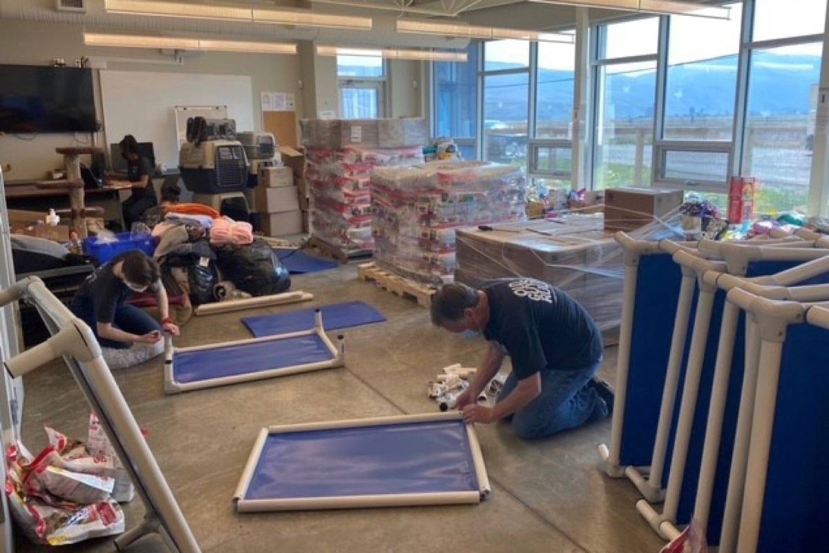
Rescued pets and livestock being taken to Kamloops for care

SPCA staff setting up a temporary Animal Evacuation Centre in Kamloops to house animals displaced from the fire in Lytton. (Photo credit: BC SPCA)

SPCA personnel going behind evacuation lines in Lytton to rescue pets and livestock

One-day window on July 8 to rescue animals and take them to temporary shelter in Kamloops

SPCA staff setting up a temporary Animal Evacuation Centre in Kamloops to house animals displaced from the fire in Lytton. (Photo credit: BC SPCA)